
Country quiz · Africa
Zimbabwe quiz
Zimbabwe comes up in 6 quizzes: 2 Explorer photos, flag, one trivia question, the Africa map and one number. Khami and Victoria Falls are among its 2 photos.
★ 4.7 on Google Play· 60 ratings· 1000+ downloads· Free
7 questions about Zimbabwe only, mixed from every pack it appears in. Scored on the spot.
Zimbabwe at a glance
| Capital | Harare |
|---|---|
| Continent | Africa |
| Location | Southern Africa, between South Africa and Zambia |
| Population | 17 million (2025 estimate), 73rd of 196 |
| Area | 390,757 km², 58th of 196 |
| People per km² | 45 |
| Land borders | Mozambique (1,402 km), Botswana (834 km), Zambia (763 km), South Africa (230 km) |
| Coastline | None, landlocked |
| Highest point | Inyangani, 2,592 m |
| Flag colours | green, yellow, red, black and white |
| Independence | 1980, from the United Kingdom |
| Calling code | +263 |
| Terrain | Mostly high plateau with higher central plateau (high veld); mountains in east |
| Climate | Tropical; moderated by altitude; rainy season (November to March) |
| Where the name comes from | Takes its name from the Kingdom of Zimbabwe (13th-15th century) and its capital of Great Zimbabwe, which was built of stone; the name Zimbabwe comes from the Bantu phrase zimba we bahwe, meaning "houses of stones;" the former name, Rhodesia, was derived from the name of British colonial administrator Cecil RHODES |
| In our quizzes | 6 packs |
Zimbabwe is landlocked and touches 4 countries; Mozambique has the longest border with it (1,402 km), South Africa the shortest (230 km). By area Zimbabwe is 58th of 196 countries, just behind Paraguay and ahead of Japan.
Facts from the CIA World Factbook and Wikidata; questions from our quiz packs. Updated .
Where it is
Places to find
2 in Explorer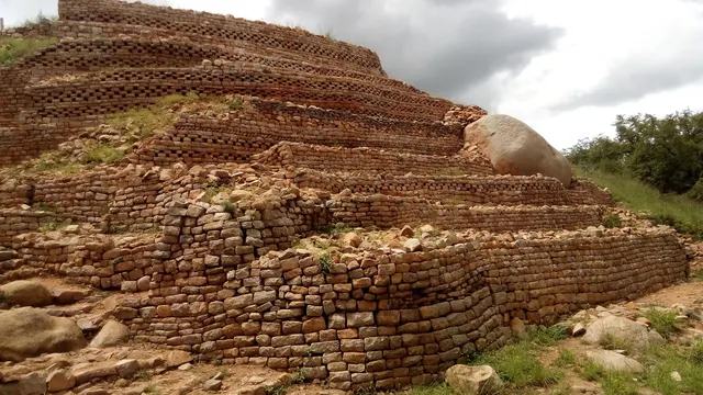
Stone-walled terraces of a 15th-century Butua capital near Bulawayo.
Photo: Todinirunganga / CC BY-SA 4.0, via Wikimedia Commons licence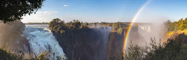
A mile-wide curtain of water thundering into a basalt gorge.
Photo: Diego Delso / CC BY-SA 4.0, via Wikimedia Commons licenceQuestions we ask
2| Question | Answer |
|---|---|
| Which country was called Rhodesia until 1979? | Zimbabwe |
| In what year did Zimbabwe gain independence? | 1980 |
Zimbabwe, question by question
The flag round shows Zambia, Mozambique and Botswana next to Zimbabwe.
Trivia asks: “Which country was called Rhodesia until 1979?” The answer is Zimbabwe. The numbers round holds independence in 1980. Explorer has 2 Zimbabwe photos: Khami and Victoria Falls.
Every Zimbabwe question, with streaks and a leaderboard, is in the app.
PlayQuestions and answers
What is the capital of Zimbabwe?
The capital of Zimbabwe is Harare.
Which continent is Zimbabwe in?
Zimbabwe is in Africa.
What is the population of Zimbabwe?
About 17 million (2025 estimate).
Which countries border Zimbabwe?
Zimbabwe borders Mozambique, Botswana, Zambia and South Africa.
What is the highest point in Zimbabwe?
Inyangani, at 2,592 m.