
Country quiz · Africa
DR Congo quiz
The DR Congo turns up 7 times across our packs: flag, 2 numbers, 2 trivia questions, the Africa map, 2 Explorer photos and outline. Angola is a wrong choice twice, for the flag and for the outline.
★ 4.7 on Google Play· 60 ratings· 1000+ downloads· Free
8 questions about the DR Congo only, mixed from every pack it appears in. Scored on the spot.
DR Congo at a glance
| Capital | Kinshasa |
|---|---|
| Continent | Africa |
| Location | Central Africa, northeast of Angola |
| Population | 119 million (2025 estimate), 13th of 196 |
| Area | 2,344,858 km², 11th of 196 |
| People per km² | 51 |
| Land borders | Angola (2,646 km), Zambia (2,332 km), Congo (1,775 km), Central African Republic (1,747 km), Uganda (877 km), South Sudan (714 km), Tanzania (479 km), Burundi (236 km), Rwanda (221 km) |
| Coastline | 37 km |
| Highest point | Pic Marguerite on Mont Ngaliema, 5,110 m |
| Official language | French |
| Currency | Congolese franc |
| Flag colours | red and yellow |
| Independence | 1960, from Belgium |
| Drives on the | right |
| Calling code | +243 |
| Largest cities | Kinshasa (16 million), Mbuji-Mayi (2.9 million), Lubumbashi (2.8 million), Kananga (1.7 million) |
| Terrain | Vast central basin is a low-lying plateau; mountains in east |
| Climate | Tropical; hot and humid in equatorial river basin; cooler and drier in southern highlands; cooler and wetter in eastern highlands; north of Equator - wet season (April to October), dry season (December to February); south of Equator - wet season (November to March), dry season (April to October) |
| Where the name comes from | Named for the Congo River, most of which lies within the DRC; the river name derives from Kongo, a Bantu kingdom in the area |
| In our quizzes | 7 packs |
Of 9 land neighbours, Angola shares the longest border with the DR Congo (2,646 km) and Rwanda the shortest (221 km); there are also 37 km of coast. By area the DR Congo is 11th of 196 countries, just behind Algeria and ahead of Saudi Arabia. Pic Marguerite on Mont Ngaliema rises to 5,110 m; only 24 countries reach higher.
Facts from the CIA World Factbook and Wikidata; questions from our quiz packs. Updated .
Where it is
Places to find
2 in Explorer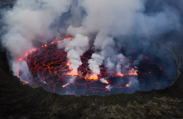
A volcano with one of the world's largest lava lakes, above the city of Goma.
Photo: Cai Tjeenk Willink (Caitjeenk) / CC BY-SA 3.0, via Wikimedia Commons licence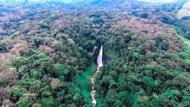
Two extinct volcanoes and the rainforest home of eastern lowland gorillas.
Photo: Public domain, via Wikimedia CommonsQuestions we ask
4| Question | Answer |
|---|---|
| Lake Kivu lies between DR Congo and which country? | Rwanda |
| What was DR Congo called from 1971 to 1997? | Zaire |
| What is the population of DR Congo? (millions) | 110 million |
| What is the area of DR Congo? (in thousand km²) | 2,345 thousand km² |
The DR Congo, question by question
The flag round shows the Congo, Angola and Gabon next to the DR Congo. The shape question offers Angola, Cameroon and Tanzania. Angola is on both lists.
Trivia asks: “Lake Kivu lies between DR Congo and which country?” The answer is Rwanda. It also asks: “What was DR Congo called from 1971 to 1997?” (Zaire). Numbers: a population of 110 million and an area of 2,345 thousand square kilometres. Explorer has 2 DR Congo photos: Mount Nyiragongo and Kahuzi-Biéga National Park.
Every DR Congo question, with streaks and a leaderboard, is in the app.
PlayQuestions and answers
What is the capital of the DR Congo?
The capital of the DR Congo is Kinshasa.
Which continent is the DR Congo in?
The DR Congo is in Africa.
What is the population of the DR Congo?
About 119 million (2025 estimate).
Which countries border the DR Congo?
The DR Congo borders Angola, Zambia, the Congo, the Central African Republic, Uganda, South Sudan, Tanzania, Burundi and Rwanda.
What is the highest point in the DR Congo?
Pic Marguerite on Mont Ngaliema, at 5,110 m.
What is the official language of the DR Congo?
French.