
Country quiz · Africa
Mali quiz
Mali turns up 6 times across our packs: flag, the Africa map, 4 trivia questions, one number and 3 Explorer photos. Tomb of Askia and Bandiagara Escarpment are among its 3 photos.
★ 4.7 on Google Play· 60 ratings· 1000+ downloads· Free
8 questions about Mali only, mixed from every pack it appears in. Scored on the spot.
Mali at a glance
| Capital | Bamako |
|---|---|
| Continent | Africa |
| Location | Interior Western Africa, southwest of Algeria, north of Guinea, Cote d'Ivoire, and Burkina Faso, west of Niger |
| Population | 23 million (2025 estimate), 60th of 196 |
| Area | 1,240,192 km², 21st of 196 |
| People per km² | 18 |
| Land borders | Mauritania (2,236 km), Algeria (1,359 km), Burkina Faso (1,325 km), Guinea (1,062 km), Niger (838 km), Ivory Coast (599 km) |
| Coastline | None, landlocked |
| Highest point | Hombori Tondo, 1,155 m |
| Currency | West African CFA franc |
| Flag colours | green, yellow and red |
| Independence | 1960, from France |
| Drives on the | right |
| Calling code | +223 |
| Terrain | Mostly flat to rolling northern plains covered by sand; savanna in south, rugged hills in northeast |
| Climate | Subtropical to arid; hot and dry (February to June); rainy, humid, and mild (June to November); cool and dry (November to February) |
| Where the name comes from | Name derives from the Mali Empire of the 13th to 16th centuries A.D.; the Mali name may come from a local ethnic group, the Malinke, whose name is derived from the words ma, meaning "mother," and dink, meaning "child" -- a reference to the matrilinear descent of Malinke families |
| In our quizzes | 6 packs |
Mali is landlocked and touches 6 countries; Mauritania has the longest border with it (2,236 km), the Ivory Coast the shortest (599 km). By area Mali is 21st of 196 countries, just behind Angola and ahead of South Africa.
Facts from the CIA World Factbook and Wikidata; questions from our quiz packs. Updated .
Where it is
Places to find
3 in Explorer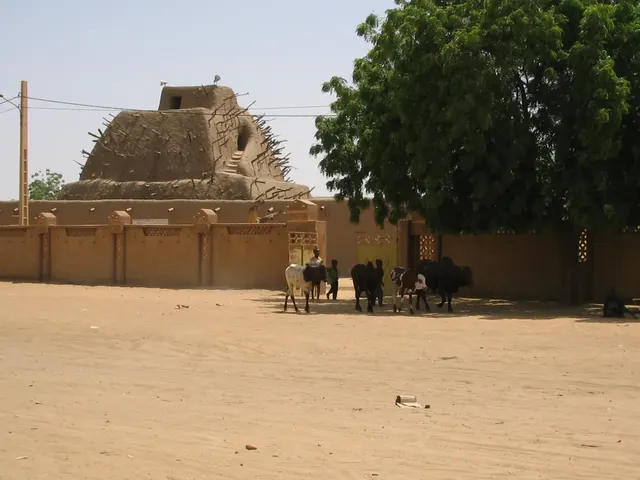
A 17-metre mud pyramid tomb of a Songhai emperor, replastered every year.
Photo: David Sessoms from Fribourg, Switzerland / CC BY-SA 2.0, via Wikimedia Commons licence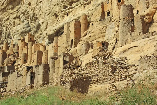
A 150-km sandstone cliff where Dogon villages cling to the rock face.
Photo: Kirua / CC BY-SA 3.0, via Wikimedia Commons licence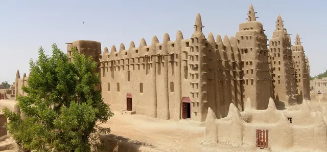
The world's largest mud-brick building, spiked with wooden beams.
Photo: BluesyPete / CC BY-SA 3.0, via Wikimedia Commons licenceQuestions we ask
5| Question | Answer |
|---|---|
| The ancient city of Timbuktu is in which country? | Mali |
| Which river flows through Mali, Niger and Nigeria? | Niger |
| Which currency do Senegal, Mali and Ivory Coast share? | CFA franc |
| The Great Mosque of Djenné, the largest mud-brick building in the world, is in which country? | Mali |
| What is the area of Mali? (in thousand km²) | 1,240 thousand km² |
Mali in our quizzes
Senegal, Guinea and Burkina Faso sit beside Mali in the flag round.
Trivia asks: “The ancient city of Timbuktu is in which country?” The answer is Mali. It also asks: “Which river flows through Mali, Niger and Nigeria?” (Niger). The numbers round holds an area of 1,240 thousand square kilometres. Explorer has 3 Mali photos: Tomb of Askia, Bandiagara Escarpment and Great Mosque of Djenné.
Every Mali question, with streaks and a leaderboard, is in the app.
PlayQuestions and answers
What is the capital of Mali?
The capital of Mali is Bamako.
Which continent is Mali in?
Mali is in Africa.
What is the population of Mali?
About 23 million (2025 estimate).
Which countries border Mali?
Mali borders Mauritania, Algeria, Burkina Faso, Guinea, Niger and the Ivory Coast.
What is the highest point in Mali?
Hombori Tondo, at 1,155 m.