
Country quiz · Asia
Turkmenistan quiz
Turkmenistan turns up 6 times across our packs: flag, the Asia map, one trivia question, capital and 2 Explorer photos. Köneürgenç and Darvaza Gas Crater are among its 2 photos.
★ 4.7 on Google Play· 60 ratings· 1000+ downloads· Free
7 questions about Turkmenistan only, mixed from every pack it appears in. Scored on the spot.
Turkmenistan at a glance
| Capital | Ashgabat |
|---|---|
| Continent | Asia |
| Location | Central Asia, bordering the Caspian Sea, between Iran and Kazakhstan |
| Population | 5.7 million (2024 estimate), 115th of 196 |
| Area | 488,100 km², 51st of 196 |
| People per km² | 12 |
| Land borders | Uzbekistan (1,793 km), Iran (1,148 km), Afghanistan (804 km), Kazakhstan (413 km) |
| Coastline | None, landlocked |
| Highest point | Gora Ayribaba, 3,139 m |
| Lowest point | Vpadina Akchanaya (Sarygamysh Koli is a lake in northern Turkmenistan with a water level that fluctuates above and below the elevation of Vpadina Akchanaya, the lake has dropped as low as, -110 m |
| Official language | Turkmen |
| Currency | Turkmenistan new manat |
| Flag colours | green, red and white |
| Independence | 1991, from the Soviet Union |
| Drives on the | right |
| Calling code | +993 |
| Terrain | Flat-to-rolling sandy desert with dunes rising to mountains in the south; low mountains along border with Iran; borders Caspian Sea in west |
| Climate | Subtropical desert |
| Where the name comes from | The suffix -stan means "land," so the country name means the "Land of the Turkmen [people];" the people's name means "Turk-like," from the Persian words tork and mandan, referring to their formerly nomadic lifestyle that differed from the settled Turks of Turkey |
| In our quizzes | 6 packs |
Turkmenistan is landlocked and touches 4 countries; Uzbekistan has the longest border with it (1,793 km), Kazakhstan the shortest (413 km). Turkmenistan is 51st in the world by area but 115th by population, so there are only 12 people per km². The lowest point, Vpadina Akchanaya (Sarygamysh Koli is a lake in northern Turkmenistan with a water level that fluctuates above and below the elevation of Vpadina Akchanaya, the lake has dropped as low as, lies 110 m below sea level.
Facts from the CIA World Factbook and Wikidata; questions from our quiz packs. Updated .
Where it is
Places to find
2 in Explorer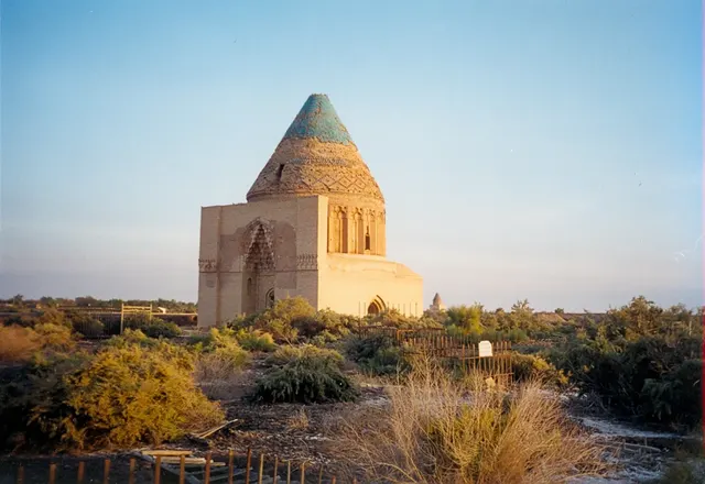
The mausoleums and minaret of a Silk Road capital razed by Genghis Khan.
Photo: Doron / CC BY-SA 3.0, via Wikimedia Commons licence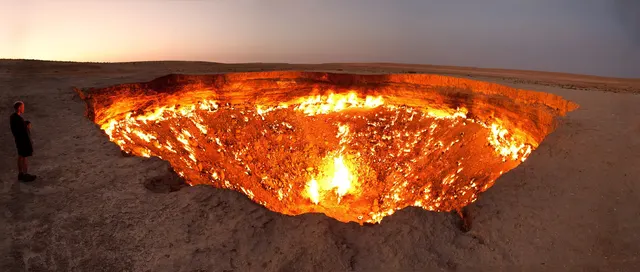
A burning gas crater in the desert, aglow day and night.
Photo: Tormod Sandtorv / CC BY-SA 2.0, via Wikimedia Commons licenceQuestions we ask
2| Question | Answer |
|---|---|
| Which country's capital is Ashgabat? | Turkmenistan |
| What currency does Turkmenistan use? | Manat |
Turkmenistan in our quizzes
Uzbekistan is a wrong choice for Ashgabat and again for Turkmenistan's flag. Uzbekistan, Kazakhstan and Tajikistan sit beside Turkmenistan in the flag round.
Trivia asks: “What currency does Turkmenistan use?” The answer is Manat. Explorer has 2 Turkmenistan photos: Köneürgenç and Darvaza Gas Crater.
Every Turkmenistan question, with streaks and a leaderboard, is in the app.
PlayQuestions and answers
What is the capital of Turkmenistan?
The capital of Turkmenistan is Ashgabat.
Which continent is Turkmenistan in?
Turkmenistan is in Asia.
What is the population of Turkmenistan?
About 5.7 million (2024 estimate).
Which countries border Turkmenistan?
Turkmenistan borders Uzbekistan, Iran, Afghanistan and Kazakhstan.
What is the highest point in Turkmenistan?
Gora Ayribaba, at 3,139 m.
What is the official language of Turkmenistan?
Turkmen.